A quiet corner where names change but the water keeps moving
South of Lincoln, the River Witham slides through flat Lincolnshire fields, past drains, sluices and quiet villages. It keeps going, as rivers tend to do, until it reaches Boston. At that point something subtle but important happens. The river stops behaving like an inland waterway and starts acting like an estuary. On maps and in harbour notices, its name shifts too. Above the town it is the River Witham. Below the Grand Sluice, it becomes The Haven – a short tidal reach that carries both fresh water and seagoing ships out to The Wash.
In other words, this is the hinge point between river and sea, between navigation locks and harbour pilots, and between fenland drains and the wide, shallow bay shared with Norfolk.
The Grand Sluice: a line on the map and a gate in the water
If we stand on the road bridge by the Grand Sluice in Boston, we are almost literally on the dividing line. On one side lies the non-tidal Witham, with its managed levels and pleasure craft heading up towards Lincoln. On the other side lies The Haven, where the tide from The Wash runs hard in and out, lifting and dropping the water against the quay walls.
The structure beneath our feet is a compact piece of eighteenth-century engineering. Built in the 1760s, the Grand Sluice consists of multiple sluice channels fitted with gates to control the river level, plus a separate lock chamber on the east bank. The sluices hold back river water above Boston and help scour the channel below, while the lock allows boats to move between river and Haven when levels match.
The tide here is not a gentle rise and fall. High water in The Wash is often above the managed river level upstream, so the gates have to resist the sea twice a day. Lincolnshire Apartments: A Warm Clear Guide to Finding Your Next Home. At low water, the Haven can be too shallow to use, which means passage through the lock is limited to a brief window on either side of each suitable tide. For boaters, this is all part of the choreography. For the rest of us, it is a reminder that gravity and salt water still dictate the timetable, even in an age of mobile phones and satnav.
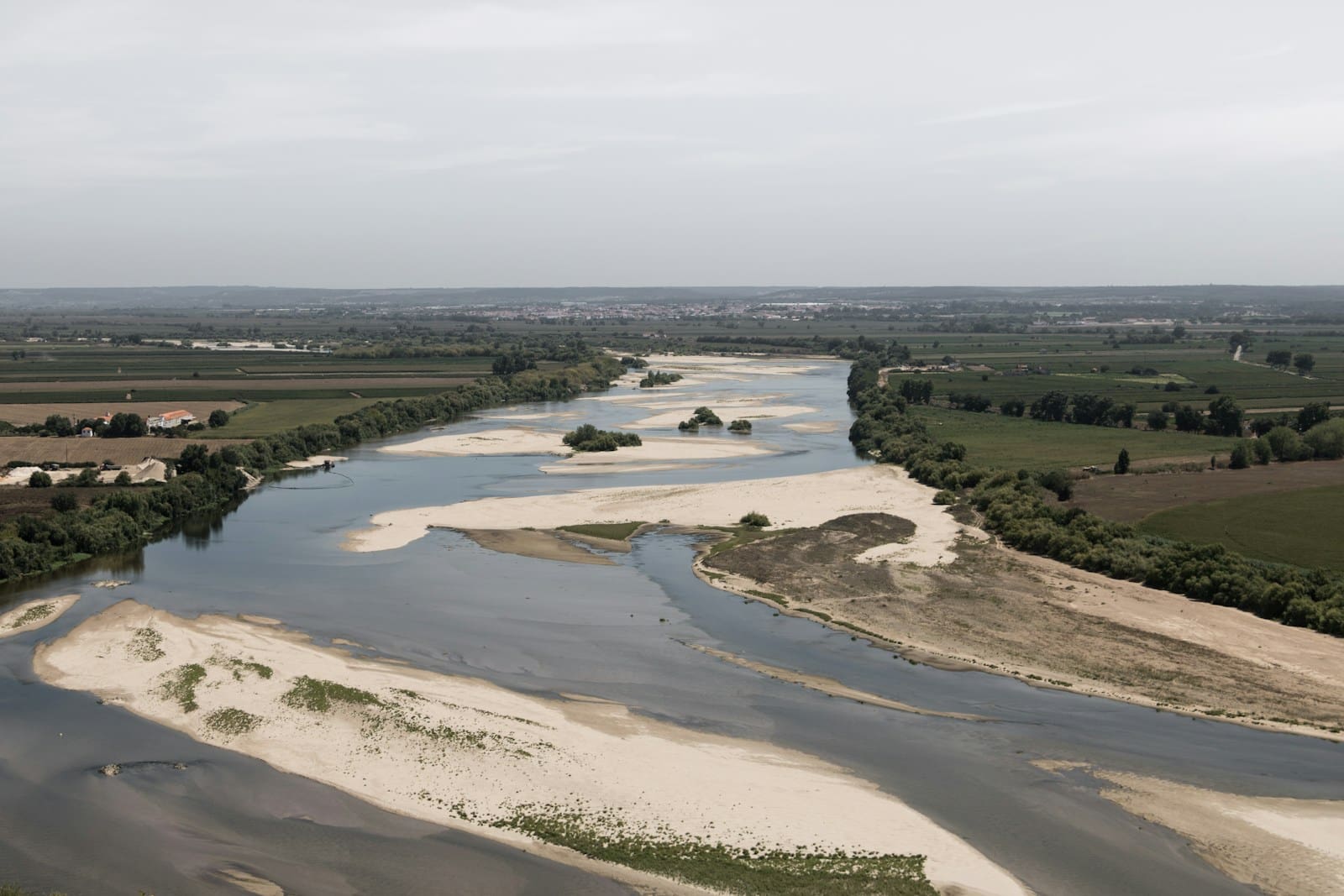
The Haven: a short tidal reach with a long list of jobs
From the Grand Sluice to the edge of The Wash, the channel is officially The Haven. On paper it is only about four miles long. In practice it works very hard for its living.
First, it is the outfall of the Witham itself, carrying the river’s fresh water out to sea. Second, it takes surplus water from some of the most heavily managed farmland in England. Drains such as the Maud Foster, Hobhole Drain and the South Forty-Foot Drain all meet the Haven, bringing water from the northern fens to this one shared exit.
Third, it is the tidal river of the Port of Boston. Ships make their way in from Boston Deeps in The Wash, follow the buoyed channel, and come up the Haven to the docks and quays that now sit below the old town centre. On harbour notices you see the dual identity written out plainly: “River Witham (The Haven)”.
So the short stretch between sluice and sea is a working funnel. Fresh water, drainage flows and marine traffic all pass through the same slightly muddy gap in the sea wall.
A river route shaped for shipping
The Haven has not always been an easy neighbour. By 1800, the tidal channel between Boston and the open sea had become broad, shallow and divided into twisting threads. Sand and silt accumulated, leaving the port vulnerable to silting and the fenland interior more prone to flooding. In other words, the town was getting the worst of both worlds: poor navigation and poor drainage.
Engineers and landowners responded in familiar ways. They straightened sections of the channel, strengthened banks and refined sluice arrangements so that fresh-water flows could cut more effectively through the mud. The aim was simple. Ships needed a reasonably stable, predictable route in from Boston Deeps. Farmland needed a reliable outlet that did not back-up at every tide. The details were less simple, as anyone who has ever tried to persuade a tidal estuary to behave will easily imagine.
The result today is a channel that looks straightforward on a map but still demands respect in real life. Currents on the bends run fast. Depths change. Silt pushes in with each tide and must be managed. For commercial vessels, harbour control keeps watch and uses radio to coordinate movements along the Haven. Market Day in Sleaford: A Tradition Still Alive. Pleasure craft do their best to fit in around working ships and the limited sluice windows.
Floodwater, defences and the Boston Barrier
The same tides that carry shipping in and out also bring risk. In December 2013 a North Sea surge forced water up into The Wash and along the Haven, overtopping defences and flooding large parts of Boston. Homes, businesses and public buildings all took in muddy water. The images travelled widely. The smell, as usual, stayed local.
After more than, the town and its engineers responded with something more ambitious than sandbags. The Boston Barrier scheme places a large moveable gate across the Haven itself, just downstream of the Grand Sluice. The gate can be rotated down into the channel to block a surge tide and raised again when levels have passed.
The scheme is designed to reduce the risk of tidal flooding to thousands of properties over the coming decades. Official figures talk about protection against very rare events, expressed as “one in several hundred year” flood probabilities. In plainer language, the barrier and associated walls give Boston and the fenland drains behind it a much better chance of staying dry when the North Sea misbehaves.
For river users, the Barrier adds another piece to the navigation puzzle. Simulations, training and clear operating procedures help skippers understand where and when they can move through the structure. The water now has one more gate to pass as it travels between Lincoln, Boston and the sea.
The Haven as a place of movement and escape
History along this stretch of water is not just engineering reports and port statistics. In 1607, a group of Separatists from inland villages such as Scrooby tried to slip out of England using a Dutch ship that was to meet them in The Haven. The attempt went wrong, arrests followed, and the episode became one of the early, awkward steps in the story that led some of those same religious dissenters towards the New World.
So the Haven has been many things. A harbour of safety for trading vessels. A risky escape route for people at odds with the authorities. A line of defence against coastal floods. A busy outfall for inland drains and a hard-worked corridor for modern shipping.
When we look down from the riverbank today at a coaster moving steadily on the tide, we are seeing only the latest chapter. Pansy Cool Wave Purple water under its bow is running over the same sands and muds that saw medieval wool exports, Puritan dramas, Victorian drainage schemes and twenty-first-century flood projects. The scene is ordinary. The backstory is not.
A boater’s route from city to sea
For those of us who travel by boat rather than by road, the River Witham and the Haven together offer a neat route from the heart of Lincolnshire to the open sea. From Brayford Pool in Lincoln, the Witham runs for around thirty-odd miles through locks at Stamp End and Bardney, along embanked river sections, until it reaches Boston and the Grand Sluice.
Above Boston, the river is fully fresh, controlled and relatively predictable. Below the sluice, everything depends on the tide. Once through the lock, a small craft shares the Haven with commercial traffic and the big fenland drains. The channel is short but exposed. The Wash lies ahead with its shifting sands and wide horizons. Behind lies an inland route back to Lincoln and, via the Fossdyke, towards the Trent.
In other words, the point where the Witham becomes the Haven is also where inland cruising quietly turns into coastal navigation. One moment we are dealing with gentle rises in lock pounds. The next we are checking tide tables and looking up VHF channels. The water is the same. The margins for error are not.
Life along the banks: town, docks and marsh edge
For people who live and work in Boston, the change from Witham to Haven can feel less dramatic and more day-to-day. Upstream, the river runs past housing, towpaths and the backs of gardens. Downstream, the Haven slips past the Stump, under new and old bridges, then out between floodbanks towards docks, industry and, eventually, open marsh.
On the upper reaches through town, waterside spaces play host to anglers, dog walkers and the odd group of cyclists. As the channel becomes more obviously tidal, the banks grow more workmanlike. Bollards, fenders and concrete aprons take over from grass, and the smell of salt mud arrives on the breeze. At low water the Haven shrinks back between glistening banks. At high water it presses up close beneath quay walls and walkways.
Further out, near the mouth in The Wash, the line between river and sea blurs almost completely. Saltmarsh and mudflat lie close by. Birds work the edges. The Stump and the cranes of the dock sit together on the horizon, one a medieval expression of spiritual ambition, Peperomia argyreia Watermelon other a modern expression of trade and logistics. The Haven, as usual, simply keeps flowing between them.
A short reach with more influence than length
Measured with a ruler, the stretch where the River Witham becomes The Haven looks unremarkable. A few miles of river, a sluice, a port and some banks.
Looked at more closely, it becomes something else. It is the outlet for a major fenland drainage system. It is the tidal approach to a long-standing port. It is the weak point for storm surges and, now, the focus of modern flood defence. It is both barrier and pathway, both risk and opportunity.
When we stand by the Grand Sluice, watching fresh water step carefully into salt, we are seeing the meeting point of inland England and the North Sea, written in mud, tide and masonry. It looks ordinary. It is anything but.